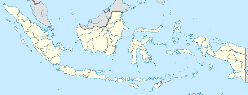
File:Indonesia location map.svg

Original file (SVG file, nominally 1,200 × 460 pixels, file size: 739 KB)
Captions
Captions
Summary[edit]
| DescriptionIndonesia location map.svg |
English: Location map of Indonesia.
Equirectangular projection. Stretched by 100.0%. Geographic limits of the map:
|
| Date | |
| Source | Own work |
| Author | Uwe Dedering |
| Other versions |
|
Licensing[edit]
- You are free:
- to share – to copy, distribute and transmit the work
- to remix – to adapt the work
- Under the following conditions:
- attribution – You must give appropriate credit, provide a link to the license, and indicate if changes were made. You may do so in any reasonable manner, but not in any way that suggests the licensor endorses you or your use.
- share alike – If you remix, transform, or build upon the material, you must distribute your contributions under the same or compatible license as the original.

|
Permission is granted to copy, distribute and/or modify this document under the terms of the GNU Free Documentation License, Version 1.2 or any later version published by the Free Software Foundation; with no Invariant Sections, no Front-Cover Texts, and no Back-Cover Texts. A copy of the license is included in the section entitled GNU Free Documentation License.http://www.gnu.org/copyleft/fdl.htmlGFDLGNU Free Documentation Licensetruetrue |
File history
Click on a date/time to view the file as it appeared at that time.
| Date/Time | Thumbnail | Dimensions | User | Comment | |
|---|---|---|---|---|---|
| current | 15:54, 4 December 2022 | 1,200 × 460 (739 KB) | NordNordWest (talk | contribs) | upd | |
| 20:17, 2 July 2022 | 1,200 × 460 (910 KB) | NordNordWest (talk | contribs) | upd | ||
| 20:21, 26 June 2013 | 1,200 × 460 (854 KB) | NordNordWest (talk | contribs) | upd | ||
| 12:58, 18 February 2010 | 1,200 × 460 (1.2 MB) | Uwe Dedering (talk | contribs) | {{Information |Description={{en|1=Location map of Indonesia. Equirectangular projection. Strechted by 100.0%. Geographic limits of the map: * N: 6.5° N * S: -11.5° N * W: 94.5° E * E: 141.5° E Made with Natural Earth. Free vector and raster map |
You cannot overwrite this file.
File usage on Commons
The following 46 pages use this file:
- Indonesia
- User:Bennylin/Maps
- Commons:Graphic Lab/Map workshop/Archive/2016
- Commons:Graphic Lab/Map workshop/Archive/2022
- File:Aceh in Indonesia.svg
- File:Bali in Indonesia.svg
- File:Bali in Indonesia (special marker).svg
- File:Bangka-Belitung in Indonesia.svg
- File:Banten in Indonesia.svg
- File:Bengkulu in Indonesia.svg
- File:Central Java in Indonesia.svg
- File:Central Kalimantan in Indonesia.svg
- File:Central Sulawesi in Indonesia.svg
- File:East Java in Indonesia.svg
- File:East Kalimantan in Indonesia.svg
- File:East Nusa Tenggara in Indonesia.svg
- File:Gorontalo in Indonesia.svg
- File:Indonesia relief location map.jpg
- File:Jakarta Special Capital Region in Indonesia.svg
- File:Jakarta Special Capital Region in Indonesia (special marker).svg
- File:Jambi in Indonesia.svg
- File:Lampung in Indonesia.svg
- File:Maluku in Indonesia.svg
- File:Maluku in Indonesia (special marker).svg
- File:North Maluku in Indonesia.svg
- File:North Sulawesi in Indonesia.svg
- File:North Sumatra in Indonesia.svg
- File:Papua in Indonesia.svg
- File:Province of Papua in Indonesia.svg
- File:Riau Islands in Indonesia.svg
- File:Riau Islands in Indonesia (special marker).svg
- File:Riau in Indonesia.svg
- File:South East Sulawesi in Indonesia.svg
- File:South Kalimantan in Indonesia.svg
- File:South Sulawesi in Indonesia.svg
- File:South Sumatra in Indonesia.svg
- File:Special Region of Yogyakarta in Indonesia.svg
- File:Special Region of Yogyakarta in Indonesia (special marker).svg
- File:West Java in Indonesia.svg
- File:West Kalimantan in Indonesia.svg
- File:West Nusa Tenggara in Indonesia.svg
- File:West Papua in Indonesia.svg
- File:West Sulawesi in Indonesia.svg
- File:West Sumatra in Indonesia.svg
- Category:2012 Indian Ocean earthquake
- Category:Indonesia
File usage on other wikis
The following other wikis use this file:
- Usage on ace.wikipedia.org
- Usage on af.wikipedia.org
- Usage on als.wikipedia.org
- Usage on an.wikipedia.org
- Usage on ar.wikipedia.org
- Usage on ast.wikipedia.org
View more global usage of this file.
Metadata
This file contains additional information such as Exif metadata which may have been added by the digital camera, scanner, or software program used to create or digitize it. If the file has been modified from its original state, some details such as the timestamp may not fully reflect those of the original file. The timestamp is only as accurate as the clock in the camera, and it may be completely wrong.
| Width | 1200px |
|---|---|
| Height | 459.574px |